Queens united over dividing lines
/Members of the New York City Districting Commission hear testimony from Queens residents about their proposal for the borough’s City Council electoral lines on Tuesday, Aug. 16, 2022, at the Museum of the Moving Image. Eagle photo by Jacob Kaye
By Jacob Kaye
Queens residents care about redistricting. So much so that a public hearing held on the proposed changes to the borough’s City Council district that began Tuesday evening didn’t end until Wednesday’s earliest hours.
In all, nearly 100 people registered to give their testimony on the New York City Districting Commission’s preliminary map, which was held on Tuesday from Astoria’s Museum of the Moving Image.
Commission members expected the testimony to take them until 1 a.m., on Wednesday, should everyone speak. In preparation, the commission told a number of registered testifiers earlier Tuesday that they would be given a chance to say their piece after 9:30 p.m., a half hour after the meeting was originally scheduled to end. The meeting wrapped up around 12:25 a.m.
Residents from nearly every City Council district in Queens appeared to agree on one thing – the proposed map, which was released in mid-July, leaves a lot to be desired.
The most common critique among residents was that racial and ethnic communities across the most diverse county in the country will be divided, and their political voices diluted, should the proposed map not undergo some significant changes.
It’s nearing the end stage for the once-in-a-decade redistricting process, which is headed by the 15-member commission led by former Schools Chancellor and current Queens Public Library Executive Director Dennis Walcott. Queens’ public hearing on the preliminary map was the first of five to take place in each borough in the coming weeks.
The maps are far from final, as the commission noted when it first released them.
Following the public hearings – one has been or will be held in each borough, though each is open to all residents of the city – the commission will craft and present its final map to the City Council, which is due by Sept. 22.
Should the council reject the plan, the commission will create a new set of maps and hold a third round of public hearings before presenting the final map to the City Clerk. Unlike the redistricting process at the state level, the legislature does not have a final veto power.
What do Western Queens and the Upper East side have in common? A council district
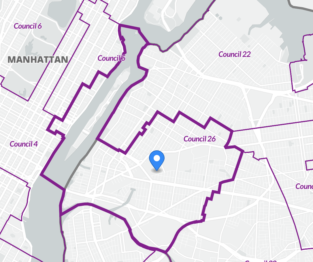
A plurality of those testifying during Tuesday’s meeting raised concerns about Council District 26, which is currently represented by City Councilmember Julie Won.
Currently, the district includes all of Long Island City, and parts of Astoria, Sunnyside and Woodside. Under the proposed maps, the district would stretch west, across the East River and pick up Roosevelt Island and a sliver of the Upper East Side in Manhattan, and it would lose a part of Astoria and all of its Woodside area.
Manhattanites and Queens residents testifying throughout the night agreed respectfully that they wanted nothing to do with one another.
A number of residents testifying during the New York City Districting Commission’s public hearing on Tuesday, Aug. 16, 2022, raised concerns about Council District 26, shown in bold. Map via Redistricting and You/CUNY Graduate Center
“Roosevelt Island is a nice place, but it's very different for the communities that are currently represented in District 26,” said Emilia Decaudin, a district leader from Sunnyside.
By picking up Roosevelt Island and a portion of Manhattan, the district’s demographics change significantly.
The district, which is home to one of the fastest growing Asian American communities in the city, would go from being around 30 percent white, to over 44 percent white under the proposal. Its Asian population would decrease from nearly 32 percent to around 25 percent – 2020 marked the first time the district elected a woman to the City Council and Won became one of the first Korean American councilmembers upon her swearing in. Its Hispanic and Black population would shrink as well.
The Sides
Part of that demographic change in District 26 would come because of the loss of Woodside.
Not only would Woodside be separated from the rest of District 26 under the proposal, it would also be separated from Sunnyside, which testifiers urged the commission to correct. Though the two neighborhoods fall under the same community board, they are not connected at all levels of government.
“If you stand at Sunnyside and you ask them where Woodside begins, or if you stand in Woodside and you ask them where Sunnyside begins, you will start an outright war because we are one community,” Won said. “We refer to ourselves as The Sides because there is no side, we are one. Sunnyside and Woodside must remain together.”
In all, Woodside would be divided into four Council Districts, including Districts 26, 30, 22 and 25.
The area is home to a number of different immigrant populations that have spent the past decade or more building community and political power in the neighborhood.
“In my experience, when it comes to the delivery of government services, it is always working class communities of color that live in neighborhoods divided into multiple districts that are ignored the most by the city,” said Nick Gulotta, a current District 26 resident.
Gulotta, who previously worked with the city’s Office of Immigrant Affairs, said that a large number of the city’s Tibetan and Himalayan community lives in Woodside and would be split under the map.
“By dividing Woodside, the proposed map would siphon many of these community members into District 30,” Gulotta added.
Assemblymember Khaleel Anderson gives testimony during the New York City Districting Commission’s public hearing inside the Museum of the Moving Image on Tuesday, Aug. 16, 2022. Eagle photo by Jacob Kaye
City Councilmember Robert Holden, who currently represents District 30, testified Tuesday and said that he agreed that Woodside should not be divided up into his district.
Holden, a registered Democrat, was first elected to the council in 2017. Though he initially lost to former City Councilmember Elizabeth Crowley in the Democratic primary that year, he ran as a Republican in the general election and won by a little more than 100 votes.
Last year, he faced an unsuccessful challenge from progressive candidate Juan Ardila, who recently won the Democratic primary for Assembly District 37. Holden won by less than 600 votes in the primary. In the general election, Holden ran on the Democratic, Republican and Conservate Party line. He received nearly 3,000 more votes as a Republican than he did as a Democrat.
The current proposal for District 30 would have the district become around 7 percent less white. Its Asian population would nearly double, and its Hispanic population – which currently represents around 33 percent of the district – would shrink by 3 percent. The district would also add on nearly 2,000 registered Democrats and a little less than 100 Republicans.
In picking up a portion of Woodside, it would lose a significant portion of Glendale, Maspeth and Woodhaven.
Rather than focus on racial and ethnic divisions, as many others did, Holden said he was concerned the districts would be dividing up neighborhoods that have similar housing stock.
“It divides the community that have the same interests, the same housing stock,” Holden said. “My recommendations for the new 30th District will maintain a consistent housing stock throughout the district.”
“Why split the neighborhoods that have the same housing stock on the southern part of the district and add large Woodside apartments,” he added. “The district kind of represents large apartments and one-to-two family homes and that's been a problem for a while.”
The Jewel of Jamaica
A number of those testifying Tuesday raised serious concerns about the proposal to split up Rochdale Village, the second-largest co-op community in New York City.
Primarily home to Black homeowners, the neighborhood is united in several major ways. It is visually a single neighborhood, connected by its architecture and confined by four major roads, one on each side. It’s connected to a shopping center on one end and a grocery store on another and features a community center.
Under the proposed maps, the southeastern portion of Rochdale Village would be split from Council District 28, which it currently is located in, and placed into District 27.
“This historic city within a city should be kept contiguous in one council district,” said Nantasha Williams, who currently represents District 27. “This current separation would disenfranchise this community…and would diminish the powerful voice that exists.”
City Council Speaker Adrienne Adams, who represents District 28, said in a statement last week that the division of Rochdale Village is one of the main decisions the commission should work to correct in the next and potentially final version of its map.
“In Southeast Queens, the draft maps threaten to significantly dilute the impact of Black voters by placing them in a new district as an overwhelming minority,” Adams said. “Rochdale Village, which is now the largest affordable co-op development of Black homeowners in Queens, continues to be separated into different districts despite being a united community that deserves to be in a singular district.”
Other concerns were raised about Southeast Queens, including Downtown Jamaica, a major retail and transit hub in the district that would be divided between Williams’ district and District 24, which is currently represented by Councilmember James Gennaro. The area is currently divided but the division would be made more significant under the proposed maps.
“[Including Downtown Jamaica in District 27] would solve so many of the ongoing projects contributing to the revitalization of the Southeast Queens community,” Williams said, adding that because the district is a transportation desert, having Downtown Jamaica’s transportation hub would allow elected officials to manage the busses that “directly serve residents from [the] district.”
How can you share your thoughts?
Queens residents who were unable to testify at Tuesday’s hearing are encouraged to register either in-person or by Zoom to testify at one of the upcoming hearings. The commission held a hearing in the Bronx on Wednesday night, and will hold another Thursday, Aug. 18, at Staten Island Borough Hall, another on Sunday, Aug. 21, at Medgar Evers College in Brooklyn and a final one on Monday, Aug. 22, at the Schomburg Center for Research in Black Culture in Manhattan.
The commission has not received as many RSVPs to testify for the other meetings as it did in Queens, but a spokesperson for the commission said they expect the Brooklyn and Manhattan hearings to be among the most well attended.
New Yorkers can also submit testimony online or submit their own proposed maps here.


